The forecast for Saturday was not good, starting bright, but then showers some heavy and brisk winds. As it turned out things were quite a lot worse than anticipated. While not needing any of the extra gear I always insist on lugging around, I would have felt foolish and vulnerable had I not been carrying it.
I started on the Moscar path towards Strines Reservoir, this was pleasantly green, and I soon met the minor road which I would follow until leaving on the path past Sugworth Hall. As tarmac sections go this was not bad at all, lovely views and a verge good enough to run on.

The footpath, part of Sheffield Country Walk, goes through a 'tradesmen's entrance' to the side of the main gate to Sugworth Hall. The main driveway is then followed before scuttling right into ancient rhododendrons. The well maintained path wriggles delightfully through the tangled shrubs. Almost as soon as one's eyes have become accustomed to the shade, they are dazzled by the light streaming through the arch that forms the exit.


As the eyes become re accustomed to daylight one can make out Boot's Tower framed in the arch (unfortunately not visible in the photo above as I neglected to use HDR mode).
The path passes within a hundred metres of the tower shortly, access is permitted though I was unaware of this at the time.

It was a real pleasure to cross this open ground, a nice grassy path firm under foot, great views all round and the weather still holding. The path starts downhill and then swings north east, approaching Strines Reservoir near its dam then following Dale Dike Reservoir. March 2014 marks the 150th anniversary of the collapse of Dale Dike Dam and the event is commemorated in Bradfield.
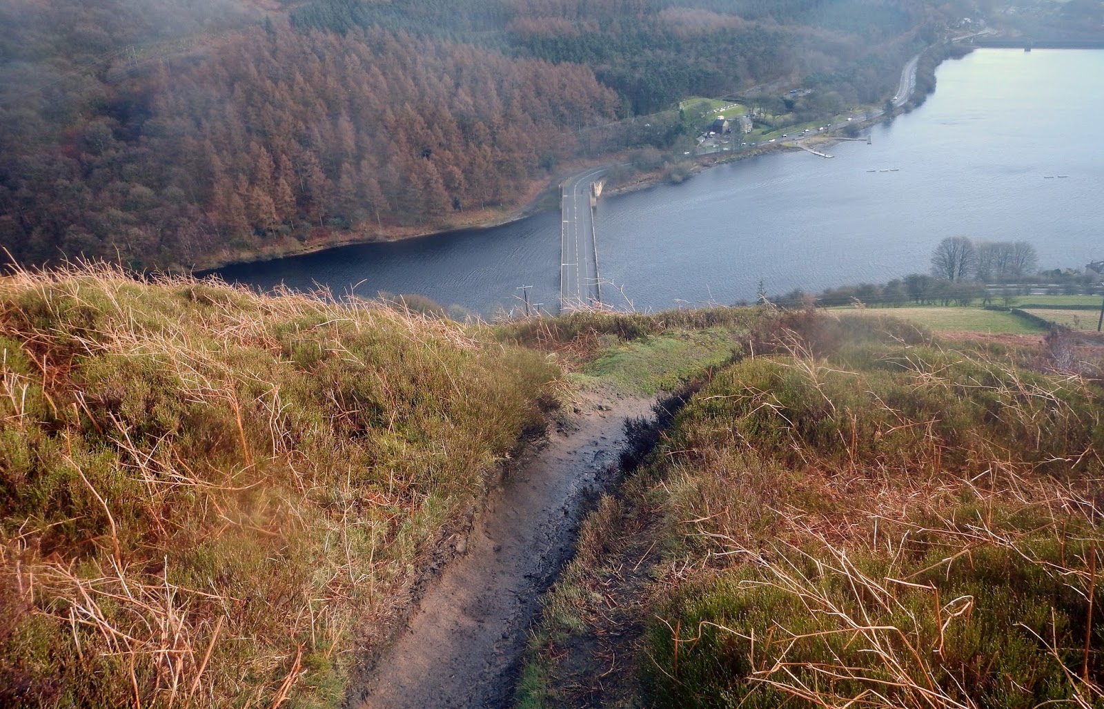
There is a choice of paths here, a lower path right on the reservoir's shore and a higher parallel path. I followed the higher path as I thought the views would be better (though it meant more tarmac later), I was not disappointed the views were superb.


The path swings up through woods to Blindside Lane, I followed the tarmac lane the couple of kilometres to Low Bradfield, there was plenty of interest. Low Bradfield is quite lovely, a model village. So much scenery behind me and only five miles into my run. I ate a bun and had a good swig of cola.
Navigation now became a little trickier than I had anticipated. My printer had failed to reproduce a rather important two centimetres of map. I had not worried unduly as I just had to follow the edge of Agden Reservoir, unfortunately it was not visible from the road in. In fact this reservoir turned out to be rather well hidden, for such a large mass of water, until one was a stones throw away.
I set off in the right general direction (north) and soon passed a Smallfield Lane, this was promising as Smallfield was the next visible thing on my map. However a rather beautiful village, hanging in the hillside above me, caught my eye and I determined to take it in. This village is High Bradfield, one of the most charming villages I have ever had the fortune to visit. The photograph below gives a taste I hope. This is somewhere I look forward to revisiting when I have time for lunch and a pint.

I left High Bradfield, with some regret and turned back for Smallfield Lane. There followed around two and a half kilometres of tarmac before swinging east across the moors on Dukes Road (path). I had checked this section of tarmac on Google Street View and it looked pretty enough, it did not disappoint.
Dukes Road would be very difficult to miss. No sooner are you on this bridleway, at first wide and well made, than the gentle views give way to bleak moorland. Looking behind me I could see the industrial cities of South Yorkshire, ahead was the High Peak, slightly left (south west) an ominous darkness was gathering. As this was the direction of the wind, I elected to get into my waterproof while I was still dry. This turned out to be a good call, by the time I had unrolled the jacket and got into it the rain was upon me, light at first, hail soon followed. There was enough wind for the hail to hurt.
I ran on until I crossed Rushy Dike. I intended to leave Dukes Road where it turns south west, however I was not sure whether the turn was clear enough to be easily noticeable. Consequently I decided to keep my eye on the time, after crossing Rushy Dike, as there was little else to navigate by. When the the bend came, it was pretty noticeable on the ground.
I left the path to head northish over the open moor, following the compass as there really was nothing to see. I was aiming just east of grid north. I wanted to meet Ewden Beck near where it is joined by Oaken Clough, it made sense to aim off to the east and follow Ewden Beck west. Eventually I saw the shooting lodge to my right and the tree lined valley ahead. I was pretty much bang on target which really had a lot to do with luck as I had had to follow groughs and detour round bog.

I made my way down the valley side, indirectly, but safely. This valley is the stuff that fairy tales are made of. Everywhere was soft green and mossy, the river tumbled between boulders while rowan and birch looked kindly on. Even the weather relented as if to smile on this magical place. It would be hard to imagine more of a contrast than between this scene and the bleak moorland I had just left. I reached the valley floor at the junction with Oaken Clough. I paused to get some photos of the stream, out of the top corner of my right eye I spotted something that was not of natural origin.
This was part of the wreckage of Short Sterling LJ628, fuselage ribs probably. LJ628 crashed onto the moor on 21st July 1944 and despite the plane being smashed to pieces all ten of the crew survived, eight of the ten walked out! I had not expected to see wreckage here as I was some way from the crash site. I was also surprised that these pieces were so large, I thought all significant stuff had been taken by the Stirling Aircraft Project in 2005.


Another aluminium rib.

As I followed the beck I saw more large pieces of the aircraft including a section of aerofoil and pivoted control surfaces. I had heard that some pieces of wreckage had been spotted remote from the crash site (at an unreported location). Maybe they have been carried here then abandoned or maybe they were blown here when they still had significant amounts of sheet metal attached to catch the wind.

I followed Stainery Clough out, the wooded valley soon gave way to open moorland again. As if to emphasise the change in scenery, the hail re started with a vengeance. Visibility became quite poor and the wind became bitter. It was time for a bite to eat, but it was too wet and cold to stop and fuss. I determined to make my way back onto the main route.
I set off on a bearing again, I had expected to run a bearing notwithstanding the weather, there would have been little to see had the visibility been better. The aim was to meet the path some way after I had left it, but before the Howden Edge/Cartledge Stones Ridge fork. I had enjoyed the path above Abbey Brook last time I was here and was determined to see more of it rather than take the shorter ridge path to Back Tor. Several mountain hares later I dropped onto the path exactly where planned, a lot of luck must have been involved as I was drifting too far east every time I checked my bearing. Somehow my guestimated course corrections seem to have worked out about right.
The narrow path high above Abbey Brook is pretty special, it is also pretty scary. The hail had beaten up a fair muddy covering on the path, I took it steady. There were gaps in the hail that allowed the odd snap, though I had nothing left that was dry enough to wipe the lens cover glass by now.

The exhilaration of the Abbey Brook path over, it was time to swing back south along the track following Sheepfold Clough and on to Lost Lad, Back Tor and then follow the Derwent Edge path back down the reservoir. The hail came hard for most of the run back, I found some shelter behind a boulder to get a bun and swap my cola bottle for a full one.

I had the option of including a planned loop taking in Bamford Edge or heading back to Cutthroat bridge. Despite the weather I was feeling OK and was well up for another six miles or so. Shortly before the descent from Derwent Edge the weather relented as if to encourage me in my endeavour. I took the 'straight off the end' path this time, an unlikely and fairly direct route to join the road for Bamford.
I crossed Ladybower on the A6103 then took the footpath down to the Derwent and Yorkshire Bridge. Here I picked up the bridleway to take the Long Tour of Bradwell route to the crossing at Bamford Mills and on up to New Road. As I left New Road and started up for Bamford Edge the weather started to close in again. I quickly took the photo below thinking that it might be the only one I would get of the Edge. As can be seen, wiping the cover glass was still a problem.

It was not long before the wind and hail reached a ferocious pitch, the hail was in my face and really painful. I pulled my buff right up and well over my nose so that it was just under my specs. Somewhat surprisingly this actually stopped my specs steaming up, this had been a significant problem when I zipped my jacket right up.
I started to feel the cold a bit, feeling in my fingertips had been something of a variable commodity for some hours, but in general I had stayed warm enough. Now the cold started to be a bit threatening, I was glad I had eaten again at Yorkshire Bridge. As I was still feeling fine I picked up my speed a little to keep warm. I took in my surroundings, felt the weather increase its efforts, chuckled a little and thought to myself, "this is where I want to be", as long as my feet don't hurt I'm good.

Despite the fact that I was still enjoying myself, the threatening cold made me glad to be near the end of my run. I took a few more pictures figuring that they would illustrate how bad the weather was if nothing else.
As I turned east towards Cutthroat Bridge the hail eased a little and for the first time I could see, in the distance, just how much had settled where conditions were favourable.
It did not take long to cover the remaining distance to the car, improving visibility meant that I could navigate by sight. I planned an optimum sequence of unlocking car doors, removing and replacing clothing, setting of the blowers and eating buns, while I ran. I was that cold.

My last bun on the inside and fibre pile on the outside I set off for Bradwell where I intended a serious raid on the Co-op. I had not warmed up fully and my teeth began to chatter as I shopped. The cashier, kindly, asked if I was OK. I explained that I had been running and would be fine once I had eaten the armfuls of food I had swept up. Another customer said that he was running a marathon, Manchester, for the first time and had just completed his last long training run. I wished him the best then set about my feast in the car park, there were no chipotle wraps this time (the falafel ones are not bad).
Another cracking run* in the Peak District. This one really had it in variety of both scenery and terrain. I must visit Ewden Beck again and the Bradfields, I also want to do even more of the Abbey Brook path.
Given the weather I was pretty comfortable and I am happy with my present gear choices. I was particularly pleased with my Montane Minimus waterproof jacket.
Sunday's ten miles at home went smoothly, I was lucky with a weather window. Old Hill looked particularly fine, the thought of it being torn up by bulldozers choked me.

Old Hill, looking fine on a March day.
*Run/walk to be accurate, the Ewden Beck section was not runnable.
No comments:
Post a Comment